
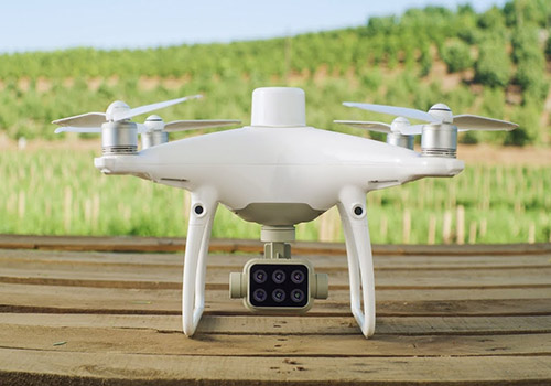
The new Phantom 4 Multispectral RTK is the first DJI model designed with the requirements of the agriculture and mapping market in mind, providing a compact solution with a 5-channel multispectral camera and additional RGB with the ability to capture RTK data with centimeter accuracy.
Available in 2 presentations:
– Multiespectral Phantom
– Multiespectral Phantom + D-RTK 2 mobile station + Tripod
Multispectral camera
Agricultural image collection is now simpler and more efficient than ever with a built-in stabilized imaging system that collects complete datasets right out of the box. Access to the information gathered by 1 RGB camera and a set of multispectral cameras with 5 cameras covering the blue, green, red bands, red border and near-infrared, all at 2 MP with global shutter, on a 3-axis stabilized gimbal.
High precision GNSS mobile station D-RTK 2.
Optimized accuracy. Complete reliability.
The D-RTK 2 Mobile Station is an improved DJI GNSS receiver that is compatible with all major satellite navigation systems. It offers real-time differential corrections that generate relative positioning information of centimeter accuracy.